Case Example - Exploration of Oil within a Salt Dome Acreage
Previously to a license claiming an onshore concession area of about 550 square kilometer was investigated by a fast and cost-effective helicopter-borne HYDROSCAN survey
In the following HYDROSCAN results within a subterritory of about 100 square kilometer are presented.
This study illustrates that HYDROSCAN method is a modern technology with a great exploration potential for detection of hydrocarbon reservoirs. It is able to define new well locations with a high productivity potential.
![]()
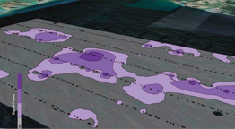
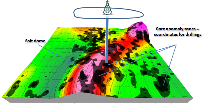
e.g. 3D plot: Oil reservoir close to a salt dome
and reservoir plays within a Jurassic trough
From the geological point of view it is a very interesting prospective acreage because source rocks and reservoir plays within a Jurassic trough are present as well as salt domes and salt pillows comprising potential oil traps within the overburden and dragging flank structures
On the other hand several decades of exploration work performed by different international petroleum companies failed which is documented by 18 dry wells and not even one productive well.
These unsuccessful results are inherent in the traditional exploration approach which comprises in general the following procedure:
In a first step anticlinal and upwarp structures are identified based on reflection seismics. In a subsequent step such defined conventional traps are drilled by chance when complex geology is predominant. In case of the treated example (zoomed area) the 5 wells unfortunately did not reveal any oil charge.
The reason is obvious when compared to the seismo-electromagnetic HYDROSCAN results.
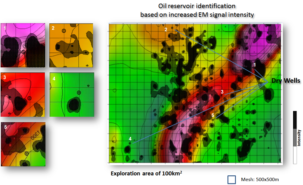
The projection of the EM signal power distribution onto the depth contour plot of Upper-Cretaceous bottom surface images the anomaly outcrop pattern of transmissible (permeable) oil-bearing reservoir zones. Thereby indicating that all dry vertical wells missed the anomaly cores (black) in off target distances of 100 - 500m.
Furthermore the HYDROSCAN survey provided additional anomaly zones outside the anticlinal areas which are not visible in the seismic data.
Based on the HYDROSCAN results a new precise well location within an anomaly core could be defined. Ongoing drilling operation discovered end of 2012 first oil evidence, thus stating a distinguished success rate of 100%..
For comparison: the long-term oil finding rate based on conventional exploration is about 17%.
![]() HYDROSCAN Case Example Onshore
HYDROSCAN Case Example Onshore
Classic Approach: Drillings on Basis of Seismic Results
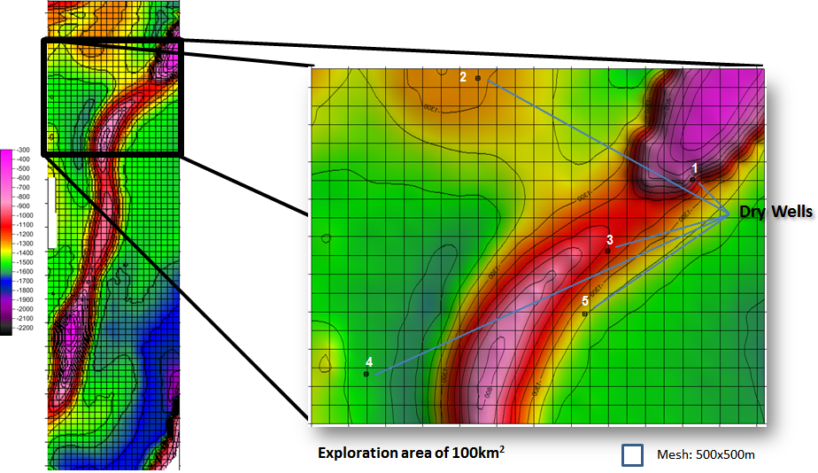
Contour plot presenting bottom depth of Upper-Cretaceous obtained from 2D reflection seismics indicating upwarp structures within the whole 550 sq.km investigation area and a zoomed area of about 100 sq.km indicating 5 dry wells
Oil Exploration by HYDROSCAN Technology
Successful Oil finding on Basis of
HYDROSCAN Results
Deliverables
Data acquisition (helicopter-borne):
![]() Continuous automatically measurement of the electromagnetic field
Continuous automatically measurement of the electromagnetic field
![]() Low and slow flights
Low and slow flights
![]() Survey line spacing >50 to 200m
Survey line spacing >50 to 200m
Data processing:
![]() Signal analysis
Signal analysis
![]() 3D inverse modeling
3D inverse modeling
Data evaluation and visualisation:
![]() Contour plots indicating receiver and source signal distribution
Contour plots indicating receiver and source signal distribution
![]() 3D visualisation of results with depth isoline plots of core anomaly zones
3D visualisation of results with depth isoline plots of core anomaly zones
Final report:
![]() Geological interpretation of geophysical results referring the hydrocarbon potential with depth estimation
Geological interpretation of geophysical results referring the hydrocarbon potential with depth estimation
Advantageous & Features

![]() Efficient de-risking tool
Efficient de-risking tool
![]() Discrimination between presence and
Discrimination between presence and
absence of oil & gas
![]() No geographical / surface / infrastructure
No geographical / surface / infrastructure
related constraints
![]() No environmental limitations
No environmental limitations
![]() No need for ground permitting
No need for ground permitting
![]() Quick turn-around
Quick turn-around
from preparation through data acquisition and processing to result
delivery with final report