Prospecting and Imaging of Ore Minerals and Graphite Resources
ORESCAN® is an innovative helicopter-borne
passive seismo-electromagnetic exploration
technology which provides detection and 3D imaging of ore mineral and graphite accumulations.
GET as the technical owner offers the full range of geophysical services comprising data acquisition, processing, 3D modlling, interpretation and reporting.
![]()
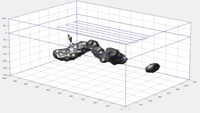
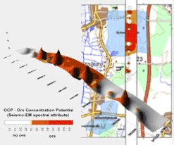
e.g. 3D plot: Ore deposit in a depth of about 300m
Airborne
Seismo- Electromagnetic Method
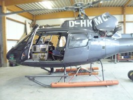
ORESCAN measurements by helicopter in rough terrain in the Canadian Rocky Mountains since 2012
ORESCAN is based on empirical results obtained over ore mineralisations, where it is found that spectral electromagnetic (EM) signals within certain low frequency (LF) narrow bands are largely raised, more than several decimal powers as compared to rocks without ore enrichment.
Hence, an ORESCAN survey enables the discrimination between presence and absence of ore/graphite occurrence comprising lateral and spatial distribution as well as a relative characterization regarding the concentration potential.
The method is directly responsive to the free electron density and quantity of ore minerals, an unique ability not available by conventional EM and other geophysical techniques.
Advantages & Features
Summarized following informations are provided:
![]() Differentiation between presence or absence of metallic ore and graphite deposits
Differentiation between presence or absence of metallic ore and graphite deposits
![]() Identification of ore and graphite, but no differentiation between different kind of
ore minerals and graphite.
Identification of ore and graphite, but no differentiation between different kind of
ore minerals and graphite.
![]() Determination of the Ore Concentration Potential (OCP) as a relative quantity
Determination of the Ore Concentration Potential (OCP) as a relative quantity
![]() 3D visualisation of results with depth isoline plots of core anomaly zones
3D visualisation of results with depth isoline plots of core anomaly zones
ORESCAN opens a wide range of highly beneficial usage for the mining industry, from frontier exploration to mine extensions, from prospect derisking to optimization of drilling placement.
Survey Method
![]() The ORESCAN airborne system consists of a high performance measuring instrumentation as well as programs for data acquisition, data processing and 3D inverse modelling.
The ORESCAN airborne system consists of a high performance measuring instrumentation as well as programs for data acquisition, data processing and 3D inverse modelling.
Case Example - Germany
Onshore Exploration
![]() A large area around the villages Midlum and Dorum in Northern Germany is prospective to find heavy mineral placers.
A large area around the villages Midlum and Dorum in Northern Germany is prospective to find heavy mineral placers.

Case Example - Canada
Onshore Exploration
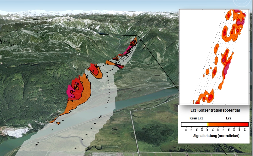
![]() In co-operation with the well established Canadian specialist Precision GeoSurveys several helicopter-borne surveys were performed since 2012.
In co-operation with the well established Canadian specialist Precision GeoSurveys several helicopter-borne surveys were performed since 2012.
Deliverables
Data acquisition (helicopter-borne):
![]() Continuous automatically measurement of the electromagnetic field
Continuous automatically measurement of the electromagnetic field
![]() Low and slow survey flights
Low and slow survey flights
![]() Survey line spacing 50 to 100m
Survey line spacing 50 to 100m
Data processing:
![]() Signal analysis
Signal analysis
![]() 3D inverse modeling
3D inverse modeling
Data evaluation and visualisation:
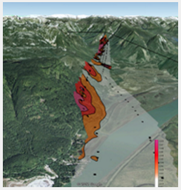
![]() Overlay contour plots comprising 3D informationen about depth and source signal intensity distribution
Overlay contour plots comprising 3D informationen about depth and source signal intensity distribution
![]() 2D and 3D visualisation of results
2D and 3D visualisation of results
Final report:
![]() Geological interpretation of geophysical results referring the ore/graphite occurence potential with depth estimation
Geological interpretation of geophysical results referring the ore/graphite occurence potential with depth estimation
Advantageous & Features
![]() Efficient de-risking tool
Efficient de-risking tool
![]() No geographical / surface / infrastructure
No geographical / surface / infrastructure
related constraints
![]() No environmental limitations
No environmental limitations
![]() No need for ground permitting
No need for ground permitting
![]() Quick turn-around from preparation through data acquisition and processing to result
delivery with final report
Quick turn-around from preparation through data acquisition and processing to result
delivery with final report
Research & Development
Extraction and analysis of the exceptional ore minerals-associated seismo-EM signals as well as the development of the required survey instrumentation and processing steps were realized in the frame of R&D projects funded by the German Ministries BMU (Environment) and BMBF (Education & Research).in 2006.